- #ElectionsWithNewsGram
- HOME
- OPINION
- ON GROUND
- INTERVIEW
- IPL 2026
- INDIA
- NewsGram USA
- WORLD
- न्यूजग्राम
- POLITICS
- ENTERTAINMENT
- CULTURE
- LIFESTYLE
- ECONOMY
- SPORTS
- Jobs / Internships
- Misc.
- NewsGram Exclusive
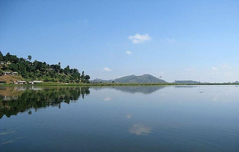
Located near Moirang in Manipur, Loktak Lake is the largest freshwater lake in the Northeastern pars of India. The lake is famous for it's 'Phumdis'; located on the largest Phundi, the Keibul Lamjao National Park, is the last refuse of Sangai (an endangered animal, also the state animal of Manipur). Currently, Loktak faces problems due to the construction of a barrage at the only outlet of the lake.

Local people construct their huts on Phumdis for fishing and other livelihood uses. Wikimedia Commons
Phumdis are a series of floating islands that cover a substantial part of Loktak lake area. They are heterogeneous masses of vegetation, soil and organic matter, in different stages of decay. The largest single-mass Phumdi covers an area of 40 km2. Local people construct their huts on Phumdis for fishing and other livelihood uses. Loktak Lake Phumdis are inhabited by about 4000 people.
The Loktak Lake is designated as a wetland of international importance under the Ramsar Convention on March 23, 1990. It was also listed under the Montreux Record on June 16, 1993, "a record of Ramsar sites where changes in ecological character have occurred, are occurring or are likely to occur".
55 rural and urban hamlets that surround the lake have a population of 100,000 people. Wikimedia Commons
Loktak Lake is a beautiful stretch of water that resembles a miniature inland sea. You can catch an aerial-type view of the lake from Sendra. The Sendra Tourist Home with an attached Cafeteria is a sought after tourist spot. Boating and other water sports are organized here at Takmu Water Sports Complex.
Loktak Lake and location of a multi-purpose Hydropower Project. Wikimedia Commons
Loktak gains its waters from Manipur river and several other tributaries. It's the only outlet is 'Ungamel Channel'. The five major rivers with an indirect catchment area of 7,157 km2 (2,763 sq mi) are the Imphal (also called the Manipur River), the Iril, the Thoubal, the Sekmai and the Khuga.
Though hydrological data on river basin has not been adequately monitored, the Department of Earth Science, Manipur University has in its report of 1996 assessed the average runoff of Manipur River as 519,200 ha·m (4,209,000 acre·ft; 5.192 km3) from a total catchment area of 697 km2 (269 sq mi) at the Ithai barrage. The groundwater potential has been assessed estimated at 44 hm3 (36,000 acre⋅ft) per annum.
Subscribe to our channels on YouTube and WhatsApp
Download our app on Play Store