
- HOME
- OPINION
- ON GROUND
- INTERVIEW
- IPL 2026
- INDIA
- NewsGram USA
- WORLD
- न्यूजग्राम
- POLITICS
- ENTERTAINMENT
- CULTURE
- LIFESTYLE
- ECONOMY
- SPORTS
- Jobs / Internships
- Misc.
- NewsGram Exclusive

Key Points
The Great Trigonometrical Survey, led by William Lambton and later George Everest, used triangulation to map India with unprecedented accuracy
Detailed maps enabled the East India Company and later British administration to improve taxation, governance, and military control
The survey transformed geography into strategic knowledge, playing a crucial role in strengthening colonial dominance over the subcontinent
‘This is utterly useless,’ these were probably the words of a class 10th student as he grappled with solving complex trigonometric equations for the first time. A general consensus of students seems to be that these complex mathematics they're wrestling with are never going to be applied in a practical setting. Giving them the benefit of doubt, exactly where one might use this equation of trigonometry in a real-life scenario?
Well, the Britishers did. It wouldn't be an exaggeration to say that they colonized the subcontinent with the aid of Trigonometry.
But how exactly did they do that? The answer lies in the history behind one of the greatest mapping surveys held in India: the great trigonometrical survey of India.
The Fourth Anglo-Mysore war waged between the East India Company (EIC)— in alliance with the Nizams and the Marathas— resulted in the defeat of Tipu Sultan in 1799. Afterwards, administering the south peninsular region proved to be an arduous task for the newly minted British Colonial government, for they did not have accurate maps of the region. The old maps of the erstwhile administration were based upon “routes surveys," meaning, the distance between two points were based upon the estimation of the distance on the paths that travellers had taken. Thus, it wasn't an accurate representation of the land.
See also: Dandi March: The Peaceful Satyagraha That Shook The Foundations Of British Imperialism
For the British, stationing troops and imposing taxation or revenue systems based upon these estimates would have been an act of utter idiocy. To effectively control a vast and diverse subcontinent, the British needed something far more precise: scientific mapping.
As the Colonizers’ hold over the region increased, so did their need for control over the land. The Britishers were in a need of accurately and well defined land boundaries, so as to efficiently station military troops and facilitate the process of in posing taxation systems and streamline governance.
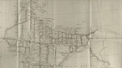
The task of mapping India scientifically was undertaken by William Lambton, a British officer and geographer. Lambton proposed the use of triangulation, a mathematical technique that uses triangles to calculate distances and positions.
This marked the beginning of the Great Trigonometrical Survey in 1802.
The process began near Madras (now Chennai), where Lambton measured a baseline of approximately 12 kilometres. This baseline was measured with precision using steel chains, held taut across the distance, carefully corrected for temperature to account for thermal expansion.
Once the baseline was established, surveyors selected a third point, often a hilltop or temple, and used an instrument called a ‘theodolite’ to measure angles between points.
With one side of a triangle and the angles known, trigonometry, specifically the law of sines, allowed them to calculate the remaining distances. By repeating this process across the landscape, they created a vast network of interconnected triangles stretching across the subcontinent, and inch-by-inch, the whole subcontinent was measured.
The process that the Britishers thought would take 5 years stretched across a whopping 70 years, as the bulky Theodolite instrument weighed over 500 kgs, and was much of a hassle, and a literal weight, to haul across large distances. The exercise, beginning at the start of the 19th century, continued through the Revolt of 1857, and lasted well after the colonial rule was administered over to the British crown from the East India Company.
See also: What would Winston Churchill make of War with Iran?
After Lambton’s death, the survey was continued by George Everest, who further refined the measurements. Everest even verified calculations by conducting manual measurements over long distances, at one point comparing 2,500 kilometres of ground measurement with trigonometric calculations, finding a difference of only a few inches.
The Great Trigonometrical Survey was not merely a scientific achievement, it was a political instrument. By mapping India with such accuracy, the British gained a decisive advantage in controlling the territory. The survey provided detailed knowledge that could be used to enforce revenue systems, plan infrastructure, and strengthen administrative control.
It also contributed to policies like the “Sunset Law,” which enforced strict revenue deadlines on zamindars, often leading to land dispossession and auctions. Such measures highlight how geographical knowledge translated directly into economic control.
During the Revolt of 1857, these maps proved invaluable for military operations. They helped the British identify routes, anticipate rebel movements, and locate hideouts, thereby strengthening their ability to suppress resistance.
This feat of the Britishers was not an uncommon one, as they accomplished what even the Mauryas and the Mughals and other dynasties could accomplish— an accurate and reliable mapping system of the region they reigned over.
Even though Trigonometry is often dismissed as abstract and impractical, it played a surprisingly significant role in shaping the history of our nation. Through the Great Trigonometrical Survey, it became a tool that enabled the British to map, understand, and ultimately dominate the Indian subcontinent.
While trigonometry did not directly conquer India, it provided the knowledge infrastructure that made colonisation more efficient and effective. It turned geography into data, and data into power.
Suggested reading:
Subscribe to our channels on YouTube and WhatsApp
Download our app on Play Store