
- #ElectionsWithNewsGram
- HOME
- OPINION
- ON GROUND
- INTERVIEW
- IPL 2026
- INDIA
- NewsGram USA
- WORLD
- न्यूजग्राम
- POLITICS
- ENTERTAINMENT
- CULTURE
- LIFESTYLE
- ECONOMY
- SPORTS
- Jobs / Internships
- Misc.
- NewsGram Exclusive

By Santosh Dubey
Today, most smartphones are equipped with navigation devices but most people do not know that the signals on these handsets are generated through satellites that are controlled by America. Global Positioning System or GPS as we know it, is operated and maintained by the US Air Force.
This means, that all your movements could be easily tracked down by the people sitting in the United States, and if need be, they can easily manipulate the navigation system which you use.
Feeling the need of having our own navigation system, country's premier space agency ISRO came up with Indian Regional Navigation Satellite System (IRNSS). IRNSS is a constellation of seven satellites of which four are already placed in the orbit.
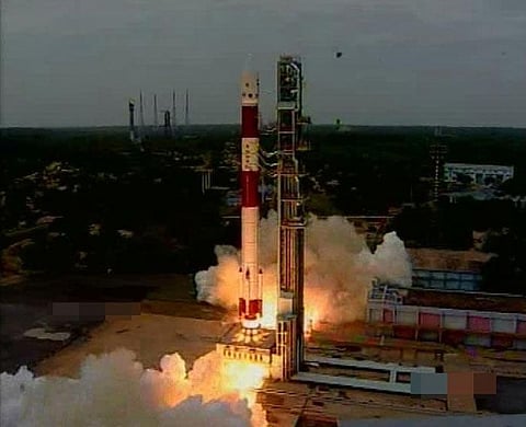
The fourth satellite of the IRNSS-1D series was put into orbit on March 28 from Sirharikota using the PSLV C-27 . With this launch, India joined the select club of six that have the indigenous capability of generating their satellite-based navigation signals within 20 minutes.
Earlier, IRNSS-1A, 1B and 1C, the first three satellites of the constellation, were successfully launched by PSLV on July 02, 2013, April 04, 2014 and October 16, 2014 respectively. All the three satellites are functioning satisfactorily from their designated orbital positions.
With this launch, the Indian Space Research Organisation can soon start operations of India's own version of the GPS, useful in everyday life for navigation. But unlike GPS, IRNSS-1D will not have its coverage worldwide.
Reach of IRNSS-1D
Its area of coverage is 1500 kms beyond Indian boundaries, mostly focusing on SAARC region. The satellite will also help the nation in mineral exploration. This Indian technology is most needed by India's armed forces for precision guidance. Not only this, the navigation system has an accuracy of less than 20 meters, which is comparable to the best in the world.
"This is the fourth satellite in a constellation of seven and it now gives India the indigenous capability for a satellite-based navigation system, this will help the common man. This will also help India helping the SAARC countries getting the benefits of satellite technology as the signals can help them as well," said Dr. Jitendra Singh, Minister of State (Independent Charge) in Prime Minister's Office and Minister for Space.
ISRO's successful journey
This is not the first time that Indian space research organisation has achieved such success. ISRO has also installed a Multi Object Tracking Radar at a cost of Rs. 245 crore for which trials would be conducted soon.
Apart from this, a reusable launch vehicle would be tested this year as a technology demonstrator.
The recent success of Indian space technology will not only benefit Indian defence but, it will add wings to the life of almost every Indians. The Indian space agency says, "Very soon India's own 'GPS' system will become operational, which would be an useful addition for the common man, but most needed by the Indian armed forces as it will give them the much needed strategic depth."
Significance of IRNSS
IRNSS is a strategic requirement for modern war-fighting. Because access to foreign government-controlled navigation satellite systems such as the American GPS or EU's Galileo is not guaranteed during hostilities — as experienced by India during the Kargil war.
Subscribe to our channels on YouTube and WhatsApp
Download our app on Play Store